About topoguide Greece
Topoguide gives access to all topoguide.gr hiking destinations with even more content than the website! The free version gives access to a demo destination: Lycabettus in Attica region. The other destinations are sold as...
Topoguide gives access to all topoguide.gr hiking destinations with even more content than the website!
The free version gives access to a demo destination: Lycabettus in Attica region.
The other destinations are sold as in-app products, each with:
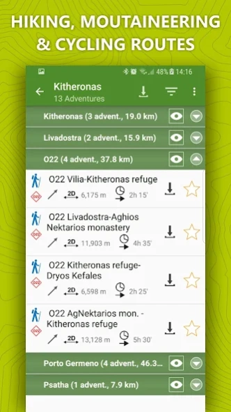
• Thousands of hiking and cyclings routes with descriptions and photos
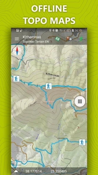
• Offline topographic maps of the area
• Guidebook with an extensive introduction on the geography, the nature and the paths of the area
• Offline search for hundreds of POIs
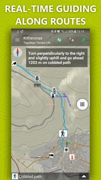
In the field, the app identifies the nearest route, guides you to it and then along it by displaying messages and warnings on every junction or other important location. On each Point of Interest, photos and texts are displayed on the map. If the hiker gets off-trail, the app indicates the shorter way to get back safely.
Topoguide's team of cartographers has previously published hundreds of detailed hiking maps for Greece. To ensure data accuracy, all routes provided in our app are walked or driven by our team.
The available destinations are:
• Long Trails : Menalon Trail, Corfu Trail, National Trail Ο22, Ursa Trail, Long Pelion Trail, Nestos-Rodopi Trail
• Attica : Athens birding, Geraneia, Hymettus, Kitheronas, Lycabettus, Parnitha, Pendeli
• Central Greece (including Thessaly): Dirfys, Elikonas, Giona, Nafpaktia Uplands, Oeta, Parnassos, Kirfis, Vardousia, Pelion (Central, Eastern, Southern & Western)
• Peloponnese : Chelmos, Elafonisos, Epidavros, Methana, Poros & Trizinia, Mani (Areopoli, Avia, Kardamili, Tenaro), Menalon Trail, Parnonas, Taygetos, Ziria
• Northern Greece (Epirus, Macedonia & Thrace): Valia Calda, Ursa Trail, Zagori
• Crete : Chania, Elafonisi, Gramvousa, Lefka Ori - Samaria
• Aegean islands (Cyclades, Saronic, Sporades & Dodecanese): Amorgos, Kea, Kythnos, Naxos, Santorini, Serifos, Sifnos, Tinos, Skyros, Kalymnos, Aegina, Hydra
• Ionian islands : Corfu Trail, Kefalonia, Zakynthos
Previous Versions
Here you can find the changelog of topoguide Greece since it was posted on our website on 2023-07-03 13:58:34.
The latest version is 1.0.21 and it was updated on 2024-04-19 17:58:17. See below the changes in each version.
topoguide Greece version 1.0.21
Updated At: 2023-05-22
Changes: 1. "Freeing" the map! Now the best map of Greece is free for streaming and simultaneous caching
2. Many minor functional changes in map and data management
3. Navigate to the start of a route using Google Maps or other navigation applications
4. Advanced navigation mechanism with 4 profiles, tracking with written navigation instructions and with storage and management of navigations
Disclaimer
Official Google Play Link
We do not host topoguide Greece on our servers. We did not scan it for viruses, adware, spyware or other type of malware. This app is hosted by Google and passed their terms and conditions to be listed there. We recommend caution when installing it.
The Google Play link for topoguide Greece is provided to you by apps112.com without any warranties, representations or guarantees of any kind, so access it at your own risk.
If you have questions regarding this particular app contact the publisher directly. For questions about the functionalities of apps112.com contact us.